09 June 2026, Raleigh: A technological revolution is taking flight at agricultural research stations in North Carolina, where autonomous drones are redefining how crop data is collected and analysed.
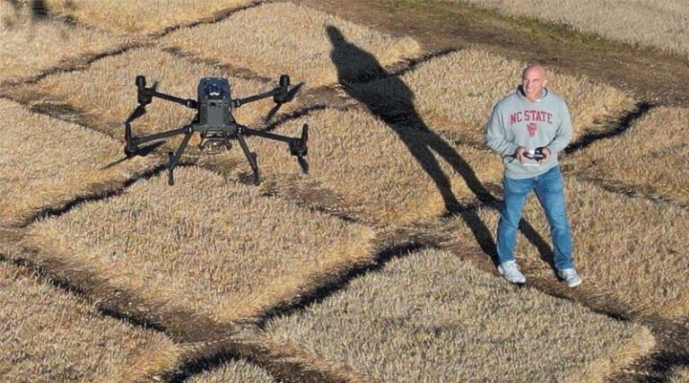
At the Sandhills Research Station in Jackson Springs, a drone emerges from a weatherproof docking station, climbs to a pre-programmed altitude and begins surveying acres of research plots. As it flies overhead, the drone captures high-resolution images that could help make agriculture more data-driven, profitable and sustainable.
Remarkably, there is no pilot standing nearby with a remote control.
Instead, the mission is launched from a computer located miles away at North Carolina State University’s campus in Raleigh. The autonomous flight is part of AIRS (Automating Intelligence from Research Stations), an initiative designed to combine drone technology, advanced imaging, artificial intelligence and digital agriculture tools to generate actionable insights for researchers and growers.
The project offers a glimpse into what many experts believe will become the future of farming: a connected ecosystem where autonomous drones, robots, sensors and AI continuously monitor crops and provide real-time intelligence to support farm management decisions.
“We can make intelligence out of that data in real time that then helps a grower make decisions,” said Chris Reberg-Horton, Director of the Resilient Agriculture Platform at NC State University’s Plant Sciences Initiative. “We want to be able to tell them, for example, ‘You have an outbreak of this disease, and it looks like it’s strongest in these fields and in these particular parts of those fields.'”
From Data Collection to Decision-Making
While drones have been used in agriculture for years, the AIRS initiative is moving beyond simple aerial imaging. The goal is to create an integrated system that can automatically collect, process and analyse data from research fields and eventually deliver real-time recommendations to farmers.
Researchers involved in the project are developing a digital infrastructure capable of handling enormous volumes of data generated by drone flights. Images are transformed into detailed orthomosaic maps, three-dimensional crop models and heat maps that can identify disease pressure, nutrient deficiencies or water stress with remarkable precision.
By standardising how data is collected and processed across research stations, scientists hope to create a long-term archive of agricultural information that can accelerate crop improvement, precision agriculture and climate resilience research.
Accelerating Crop Research Through Drone-Based Phenotyping
One of the immediate benefits of drone technology is its ability to dramatically improve crop phenotyping, the process of measuring plant characteristics such as growth, health and disease resistance.
Traditional methods often require researchers to walk through thousands of plots taking measurements manually. Drones can perform the same task in a fraction of the time while capturing information that would otherwise be impossible to collect at scale.
“With drones, you just need the time to fly once a week,” said Joe Gage, Assistant Professor of Crop and Soil Sciences. The technology enables researchers to monitor crop development continuously throughout the growing season, generating valuable insights for plant breeding programmes and crop improvement efforts.
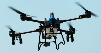
The Rise of Autonomous Drone-in-a-Box Systems
Perhaps the most significant innovation is the deployment of autonomous “drone-in-a-box” systems.
Housed in weatherproof stations, these drones can operate remotely without requiring researchers to travel to field sites. This not only reduces costs but also allows data collection to occur more frequently during critical growth stages.
“We have the drone at the site, and some of us can just operate the drone from Raleigh,” said Frank Bai of the Department of Biological and Agricultural Engineering. “That will save us a lot of money, because everything’s automatic.”
The technology is currently supporting research into drought-tolerant soybean varieties, enabling scientists to conduct frequent flights and better understand crop responses to changing environmental conditions.
Building the Smart Farms of Tomorrow
Researchers believe autonomous drones are only the beginning.
Future farms could feature interconnected networks of drones, robotic field vehicles, sensors, tractors and harvesting equipment, all generating continuous streams of data that AI systems analyse in real time.
“The day is coming when farms will have images of what’s happening all across their fields coming in from their combines, their planters, their tractors, from robots working the fields and from drones overhead,” Reberg-Horton said. “Our research stations can be testbeds for making that happen.”
As agriculture faces increasing pressure to produce more food with fewer resources, technologies that improve efficiency, sustainability and decision-making are becoming essential. Autonomous drones and AI-powered data collection systems may soon become indispensable tools for growers around the world.
“The beauty of that is we can derive intelligence from those images to help growers make real-time decisions that have a positive impact for them and, ultimately, for consumers,” Reberg-Horton added.
Global Agriculture is an independent international media platform covering agri-business, policy, technology, and sustainability. For editorial collaborations, thought leadership, and strategic communications, write to pr@global-agriculture.com